bicycle, cycling, commuting by bicycle, mountain bike, riding bicycles, group ride, power tap, bike racing, bmx
Monday, August 27, 2012
The New River Trail - Foster Falls, VA. to Galax, VA and back 8/26/12
Click on the photos to enlarge them
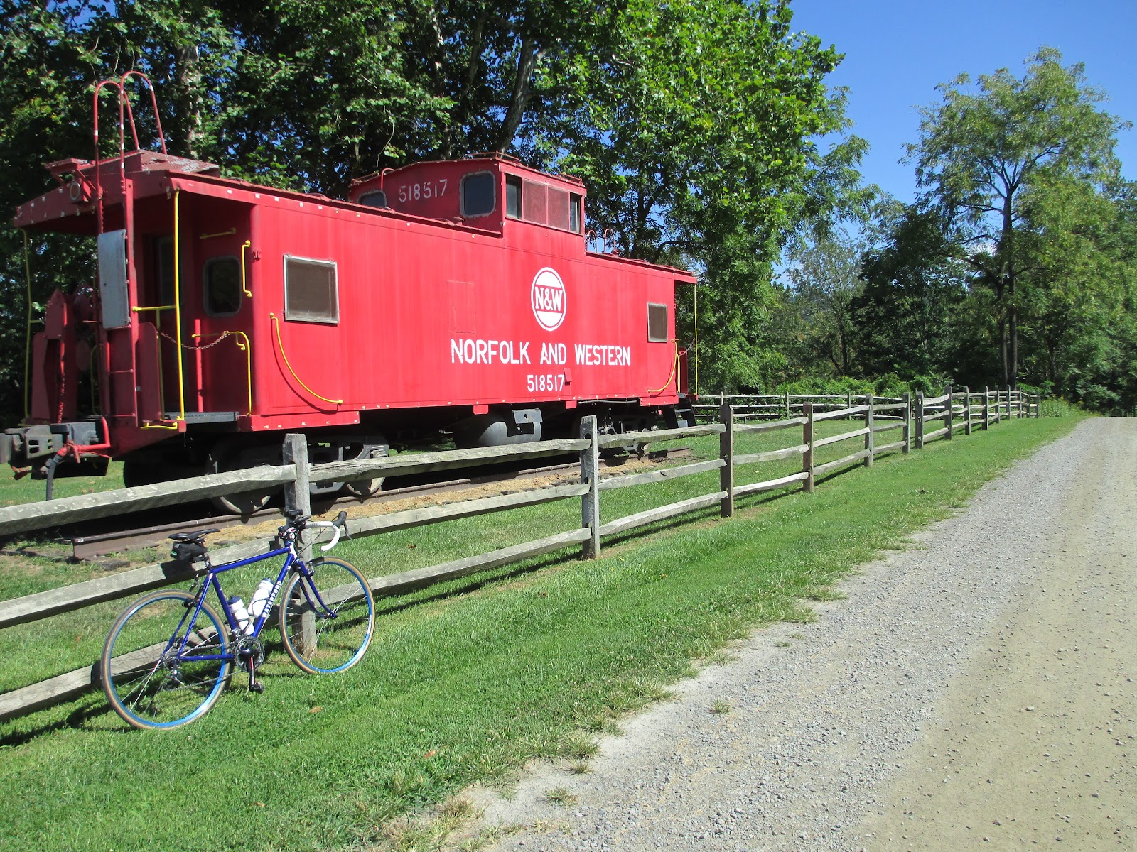
Out of service Norfolk and Western Caboose on display at Foster Falls, VA.
It's been about a year since I last rode on the New River Trail. I always enjoy riding there, so I headed that way Sunday afternoon to go for a ride. I parked at Foster Falls and rode to Galax, Va and back. My ride totaled 50 miles. Between Foster Falls and Galax the trail goes through two tunnels and crosses two long bridges. There are many short bridges along the way as well. The trail runs from Galax to Pulaski, Va. and is 51.5 miles long in one direction and parallels the New River for 39 miles. The New River is one of the few rivers in the world that runs north. There is a branch of the New River Trail that goes to Fries, Va. that is an additional 5.5 miles. In Fries there are a couple of restaurants close to the trail. This makes Fries a good destination or place to start and end your ride. The trail is open to bicycles, hikers and equestrian. Motorized vehicles are not allowed. Click here for more information on the New River Trail.
History form the New River Trail State Park web site: In December 1986, Norfolk Southern Corporation donated a 57-mile tract of abandoned railroad right-of-way to the Commonwealth of Virginia for the establishment of a new state park. Because railroad tracks had previously been on the strip of land, the cinder roadbed needed very little grading. With the help and support of volunteer groups and chambers of commerce in the region, the park was able to open in May 1987 with four miles of trail. Since then approximately 57 miles of the park are open to the public.
Foster Falls, Va is a good access point for the New River Trail. There is a state run store with clean restrooms and plenty of parking. The parking fee is $2.00 on weekdays and $3.00 on weekends.
The town of Foster Falls was built around the iron industry in the late 1800s and early 1900s. There was a large iron furnace built in 1880-1881 by the Foster Falls Mining and Manufacturing Co. The railroad was used to ship pig iron to far away manufacturing centers. During it's peak Foster Falls had the iron furnace, a large hotel, a railroad station, a grist mill, a saw mill, a dry goods store, a distillery and more than 100 homes. All that remains of the community today are the Methodist Church, a post office, a few homes and deserted buildings along the river.
The train depot at Foster Falls, Va has been converted into a park office and store.
An old railroad trestle converted into a bridge for the New River Trail
The structure of the bridge over Indian Branch. There are over 30 bridges on the trail.
One of the two tunnels on the trail.
The tunnel behind me is 135 feet long and carved completely out of stone.
The Ivanhoe Bridge over the New River is 670 feet long.
The view of the New River looking north from the Ivanhoe Bridge.
The view of the New River looking south from the Ivanhoe Bridge.
A view of the New River from the trail. It's difficult to see but there is someone fishing from the rocks in the middle of the river.
I zoomed in on the rocks to photograph who was fishing in the river. It's Mr. Great Blue Heron. I look for Blue Herons as I pass by ponds on my road rides through the country side. I see the Blue Heron quite often but it is rare that I see a Great Blue Heron. The Great Blue Heron is the largest North American Heron. They have a head-to-tail length of 36- 54 inches and a wingspan of 66 - 79 inches. This Heron was suspicious of me as I took my camera out and took a couple of photographs. It flew away above the river, looking like a giant pre-historic bird, and calling in a harsh voice.
There are many shorter bridges like this one on the trail.
The Byllesby/Buck Hydroelectric Dam at Ivanhoe, VA.
Where ever the trial crosses a road there are these yellow gates that slow trail users and helps to keep motorized vehicles off the trail. At this point the trail crosses a gravel road.
This is a typical section of the trail.
The Fries Junction. It's 12 miles to Galax, VA and you cross the longest bridge on the trail to the left. If you turn right here it's 5 miles to Fries, VA.
There are restrooms approximately every 10 miles on the trail. The one in the photo above is at the Fries Junction. That's a hitching post for horses in the foreground of the photo.
This bridge at the Fries Junction is 1,089 feet long and the longest bridge on the New River Trail.
The Fries Junction Bridge over the New River.
The view of the New River from the Fries Junction Bridge.
This tunnel is on the way to Galax, VA after passing the Fries Junction and at 193 feet it is the longest tunnel of the two on the New River Trail.
Inside the longest tunnel on the New River Trail.
There are many tidy places to take a break along the trail like this one above. It features a covered table, bike rack, hitching post and trash cans. I didn't see any litter along the trail at all.
This is a curved bridge over Chestnut Creek. The trail crosses Chestnut Creek several times.
The sun was making the tar bubble up out of the railroad ties used on this converted trestle. The smell of the tar made me imagine an old steam engine crossing this bridge.
Another bridge over Chestnut Creek.
A view of Chestnut Creek from the bridge.
The trail head at Galax, VA. There is plenty of parking and clean restrooms here. There is a CVS drug store across the street from the parking area in Galax.
A hill side of cows grazing at the Triple C Farm alongside the New River Trail.
Shortly after leaving Galax and headed back to Foster Falls I saw my friend James and his wife riding on the trail. They rode from Galax to Fries and back. That is James's authentic dutch Gazelle brand bike on the left of the photo. My first good road bike was a Gazelle made in Holland.
A view of the New River from the trail.
I had a great time riding on the New River Trail. Be sure and take more food and water than you think you might need when riding on the trail. Opportunities to buy food and beverages are few and far between on the trail. I saw many different types of bikes on the trail. Most of them where comfort or mountain bike type bikes. I rode a cyclo-cross bike with 700x28mm road tires inflated to 80 psi. Most any type of bike will work well on this trail surface. From previous experience I have found that if the trail is wet your tires will sink into the surface and it can be very hard to pedal. It takes more energy to ride on soft surfaces than it does to ride on paved surfaces. Be conservative when selecting your route and distance.
When ever I ride on a rails-to-trails I always imagine steam powered locomotives following the same route. I can almost here the distant whistles of long retired steam engines. Below is a serious of informative videos on steam locomotives.


No comments:
Post a Comment